Nordic maps

Severské mapy

Hledáte přesnou a podrobnou mapu pro svou dovolenou ve Skandinávii? Chystáte se na trek po norských horách? Vyberte si z našich map, které dovážíme přímo od norských vydavatelů. Především turistické mapy jsou velmi odolné rozmarům počasí. Máme i přehledné automapy s českými vysvětlivkami.

Severské mapy

Grid
List

There are 132 products.

Showing 1-20 of 132 item(s)

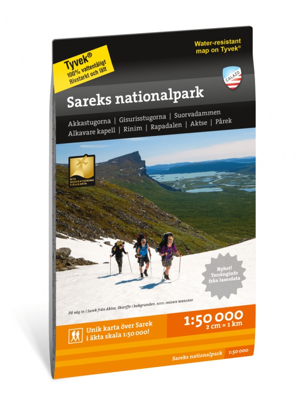
Z51 Are - tourist map 1:50 000

Detailed tourist map Are. Suitable for tourist guides, travelers and adventurers. Roads for snowmobiles are also marked. The map is printed on paper that resists weather. Texts only in Swedish, well-arranged information and legend in English and German.
Kč 659
In Stock
View Detail

Veikart Norge 1:1mil. - map of Norway

Norwegian folding car park and the Spitsbergen archipelago with a rich register of places on the back. The latest edition of the Road Statement to the beginning of 2017. Table of Distances. Labels in Norwegian, English and German. Scale 1: 1 mil.
Kč 659
zašleme do 24 hodin
View Detail

Veikart Nord-Norge Nord 1:500 000

The last 5th part of north Norway's folding automapap (northern part) with a rich register of places on the back. Includes areas and cities of Tromso, Alta, Hammerfest, Honningsvag, Nordkapp, Vardo, Kirkenes. The latest edition of the Road Statement to Begin 2016. The Distance Table. Labels in Norwegian, English and German. Scale 1: 500,000.
Kč 659
zašleme do 24 hodin
View Detail

Vasaloppet Arena 1:50 000 - mapa závodu

Mapa legendárního běžkařského závodu Vasaloppet ze Salenu do Mory. Mapa obsahuje i turistickou trasu (Vasaloppsleden) a cyklistickou trasu (CykelVasaleden). Trasa měří cca 90 km a vede přes známá místa jako Mangsbodarna, Evertsberg, Hogberg do městečka Mora, kde se můžete proběhnout po cílové rovince. Vydáno ve Švédsku. Texty ve švédštině, popisky i v...
Kč 549
In Stock
View Detail

Valdresflye, Nasjonale turistveger

Map of the National Autoturist Route through the Valdresfly Pass at a scale of 1: 50,000. There are also 5 quality views from this area of ​​Norway. The stacked map is in the hardboard cover. Information in English, Norwegian and German.
Kč 659
In Stock
View Detail

Turkart Senja - tourist map 1:50,000

This double-sided tourist map covers the entire island of Senja with its high, steep mountains and typical alpine feel. It is part of Calazo's modern map series with unique terrain information based on laser scanning from aircraft. Thanks to the Tyvek® material, it is completely waterproof and highly tear-resistant.
Kč 549
In Stock
View Detail

Turkart Rondane - tourist map 1:50,000

This double-sided hiking map covers the whole of Norway's oldest national park, Rondane, with classic hiking destinations such as Rondvassbu, Bjornhollia, Rondeslottet (2178 nm) and Hogronden (2115 nm). The map covers all the most popular mountain areas, marked hiking trails in the vicinity, DNT cabins and private accommodation cabins. It shows marked...
Kč 549
Out-of-Stock

Trondheim 1:50.000

Detailed map of Trondheim and region. Detailed map in 1:50 000 scale. Detailed mapping of hiking trails and mountain chalets. Suitable for navigation on and off marked roads. Released in Norway.
Kč 659
zašleme do 24 hodin
View Detail

Tromso a Lyngsalpene CK42 - hiking map 1:100/1:50 tis.

A detailed tourist map of popular Tromso and the Lyngalpane Mountains on a scale of 1: 50,000 and the islands of Kvaloy and Ringvassoya on the scale of 1: 100,000. Printed on waterproof paper, information on hiking routes and DNT huts. Marked as well as winter skiing routes and modified paths. Released in Norway.
Kč 769
Out-of-Stock

Trolltunga, Odda - Ullensvang 1:50.000

Detailed map of Trolltunga, Odda - Ullensvang. Detailed map in 1:50 000 scale. Detailed mapping of hiking trails and mountain chalets. Suitable for navigation on and off marked roads. Released in Norway.
Kč 714
zašleme do 24 hodin
View Detail

Tourist map Romsdalseggen 1:25 000

The most detailed tourist map of Romsdalseggen, includes Trollstigen, Trollveggen, Romsdalshornet, Andaslnes, Isfjorden Detailed map in 1:25 000 scale. Suitable for navigating on and off marked trails. Released in Norway.
Kč 714
In Stock
View Detail

Tourist Map Breheimen 1: 50.000

Detailed tourist map of the Breheimen National Park. Detailed map in 1:50 000 scale. Detailed mapping of hiking trails and mountain chalets. Suitable for navigation on and off marked roads. Released in Norway.
Kč 659
In Stock
View Detail

Sodra Gotland 1:60,000 - tourist map of the island

The 1:60,000 scale waterproof terrain map of Sodra Gotland is perfect for those of you who are hiking or cycling on the island, or if you just want to find your way down by car to one of the semi-secret beaches. The northern part of Gotland + Faro can be found under the name Norra Gotland + Faro.
Kč 494
In Stock
View Detail

Sarek National Park - turistická mapa 1:50.000

Podrobná turistická mapa švédského národního parku Sarek. Vhodná pro turistické průvodce, cestovatele a dobrodruhy. Vyznačeny i cesty pro sněžné skútry. Mapa je vytištěna na papír, který odolá počasí. Texty pouze ve švédštině, přehledné informace a legenda i v angličtině a němčině.
Kč 549
Out-of-Stock