Grid
List

There are 82 products.

Showing 21-40 of 82 item(s)

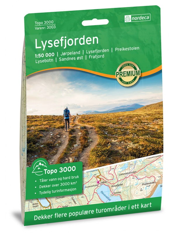
Hiking map Lysefjorden 1:50.000

Detailed tourist map of Lysefjorden, Preikestolen, Kjerag, etc. Detailed map in 1:50 000 scale. Detailed map of hiking trails and mountain chalets. Suitable for navigation on and off marked roads. Released in Norway.
Kč 714
Out-of-Stock

Map Lofoten, Nasjonale turistveger

Map of the National Car Route on the Lofoten Archipelago at a scale of 1: 100,000. There are also 5 quality views from this area of ​​Norway. The stacked map is in the hardboard cover. Information in English, Norwegian and German
Kč 659
Out-of-Stock

Map Jaeren, Nasjonale turistveger

Map of the National Carriage Route through the coastal region Jaeren under Stavanger at the scale of 1: 100,000. There are also 5 quality views from this area of ​​Norway. The stacked map is in the hardboard cover. Information in English, Norwegian and German.
Kč 659
In Stock
View Detail

Rallarvegen 1:50.000

Detailed tourist and cycle map of the Rallarvegen area. Detailed map in 1:50 000 scale. Detailed mapping of hiking trails and mountain chalets. Suitable for navigation on and off marked roads. Released in Norway.
Kč 659
zašleme do 24 hodin
View Detail

Hoyfjellskart Jotunheimen: Galdhopiggen + Glittertind -...

A unique map with a lot of detail that has never been shown before in a map of Norway's highest mountain range. It is ideal for those planning to climb Galdhopiggen (2469 m). Terrain information on the map is based on laser scanning from an aircraft. For the first time, mountain slopes, larger rocks, watercourses and glaciers appear with an accuracy that...
Kč 659
In Stock
View Detail

Balestrand Tourist Map 1:50 000

A detailed tourist map of the Sognefjord, includes Balestrand, Vangsnes, Hella, Dragsvik, Gaularfjellet Mountain Road. Detailed map in 1:50 000 scale. Suitable for navigating on and off marked trails. Released in Norway.
Kč 714
In Stock
View Detail

Hoyfjellskart Hogruta - tourist map 1:25.000

Hogruta Jotunheimen leads through the most beautiful mountain passes and the highest peaks of Scandinavia. This 1:25,000 scale alpine map contains terrain information based on laser scanning from an aircraft. The map shows the "original" Hogwarts from 2014, as well as various frequently used alternatives. Thanks to the Tyvek® material, it is completely...
Kč 549
In Stock
View Detail

Rondane, Nasjonale turistveger

Map of the National Autoturist Route through the Rondane National Park at a scale of 1: 55,000. There are also 5 quality views from this area of ​​Norway. The stacked map is in the hardboard cover. Information in English, Norwegian and German.
Kč 659
In Stock
View Detail

Hoyfjellskart Jotunheimen: Galdhopiggen & Glittertinden -...

The highly detailed hiking map of Scandinavia's highest mountains is unique in that the terrain information on the map is based on laser scanning from an aircraft. Mountain slopes, waterways, glaciers and other natural elements are shown in much more detail with this technology. The map also contains more trails than any previous map of the same area. The...
Kč 549
In Stock
View Detail

Trolltunga, Odda - Ullensvang 1:50.000

Detailed map of Trolltunga, Odda - Ullensvang. Detailed map in 1:50 000 scale. Detailed mapping of hiking trails and mountain chalets. Suitable for navigation on and off marked roads. Released in Norway.
Kč 714
zašleme do 24 hodin
View Detail

Helgelandskysten, Nasjonale turistveger

Map of the National Car Travel Route along the coast along Route 17 - Helgelandskysten on a scale of 1: 250,000. There are also 5 quality views from this area of ​​Norway. The stacked map is in the hardboard cover. Information in English, Norwegian and German.
Kč 659
Out-of-Stock

Hoyfjellskart Senja: Keipen, Tredjefjellet & Kvanan -...

Tourist map showing the northwestern part of Senja Island at a scale of 1:25,000. Useful especially if you are planning a trip to the top of Keipen (938 m), Breitinden (1001 m) or Kvanan (963 m) or you want to leave the marked paths and go into the mountains on your own fist. Thanks to the Tyvek® material, it is completely waterproof and highly...
Kč 549
In Stock
View Detail

Lysefjorden 1:50 000 TOPO 3000

Detailed map of Lysefjorden and places of interest, including Preikestolen - Lysebotn - Sandnes ost - Frafjord, Kjerag and more. Made of weather-resistant paper. Double-sided, scale 1:50 000. Includes over 3000 km2. Released in Norway.
Kč 769
Out-of-Stock

Atlanterhavsvegen, Nasjonale turistveger

Map of the National Autoturistical Route Atlanterhavsvegen along the bridges and islands on the Atlantic Ocean between Molde and Kristiansund. There are also 5 quality views from this area of ​​Norway. The stacked map is in the hardboard cover. Information in English, Norwegian and German
Kč 659
In Stock
View Detail

Folgefonna 1:50 000 TOPO 3000

Detailed tourist map of the Folgefonna glacier and the surrounding area, including places like Tyssedal, Trolltunga and others. Made of weather-resistant paper. Double-sided, scale 1:50 000. Includes over 3000 km2. Released in Norway.
Kč 769
Out-of-Stock

Roadmap Norway 2016 1:1,1 mil. CK13 Hele Norge

Norwegian folding car park and the Spitsbergen archipelago with a rich register of places on the back. The latest edition of the Road Statement to Begin 2016. The Distance Table. Labels in Norwegian, English and German. Scale 1: 1.1 million
Kč 714
zašleme do 24 hodin
View Detail