Maps Norway

Norsko

Do Norska jedině s mapou od nás. Dovážíme přesné a podrobné mapy vydané v Norsku. Obsahují aktuální stavy silnic i plánované nové úseky. Dovíte se kde je třeba zastavit a kudy povede trasa vašeho výletu.

Norsko

Grid
List

There are 51 products.

Showing 1-20 of 51 item(s)

Active filters

  • Availability: In stock

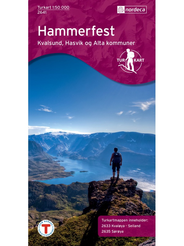
Hammerfest Tourist Map, Kvaloya + Soroya, 1: 50.000 - 2 maps

Two maps in one package. Detailed tourist map of the fishing area of Soroya, Kvaloya, Hammerfest. It contains parts of the districts of Kvalsund, Hasvik and Alta in the north of Norway. Detailed map in scale 1:50 000. Detailed drawing of hiking trails and mountain huts. Suitable for navigating on and off marked trails. Released in Norway.
Kč 1,209
In Stock
View Detail

Trolltunga, Odda - Ullensvang 1:50.000

Detailed map of Trolltunga, Odda - Ullensvang. Detailed map in 1:50 000 scale. Detailed mapping of hiking trails and mountain chalets. Suitable for navigation on and off marked roads. Released in Norway.
Kč 714
zašleme do 24 hodin
View Detail

Roadmap Norway 2016 1:1,1 mil. CK13 Hele Norge

Norwegian folding car park and the Spitsbergen archipelago with a rich register of places on the back. The latest edition of the Road Statement to Begin 2016. The Distance Table. Labels in Norwegian, English and German. Scale 1: 1.1 million
Kč 714
zašleme do 24 hodin
View Detail

Map of Nordkapp - Norge Serien 1:50 000

Map of Nordkappa, the northernmost Cape of Norway on the island of Mageroya. contains the town of Honningsvag, the fishing villages kamoyvaer, Gjervaer, Skarsvag and the route to Knivskjelodden. Detailed scale 1:50 000.
Kč 769
In Stock
View Detail

Galdhopiggen 1:25.000, hiking map

Detailed tourist map of the highest mountain Scandinavia Galdhopiggen in Jotunheimen Park. Drawn access roads from the catchment of Juvasshytta and the village of Spiterstulen. A detailed map in the 1:25 000 scale. Winter skiing routes are also marked. Suitable for navigation on and off marked roads. Released in Norway.
Kč 659
In Stock
View Detail

Mapa Aurlandsfjellet, Nasjonale turistveger

Aurlandsfjellet National Road Map (Route No. 243) at a scale of 1: 50,000. It features famous places like Stegastein, Naeroeyfjord, the Laerdal tunnel. There are also 5 quality views from this area of ​​Norway. The stacked map is in the hardboard cover. Information in English, Norwegian and German.
Kč 659
In Stock
View Detail

Veikart Nord-Norge Nord 1:500 000

The last 5th part of north Norway's folding automapap (northern part) with a rich register of places on the back. Includes areas and cities of Tromso, Alta, Hammerfest, Honningsvag, Nordkapp, Vardo, Kirkenes. The latest edition of the Road Statement to Begin 2016. The Distance Table. Labels in Norwegian, English and German. Scale 1: 500,000.
Kč 659
zašleme do 24 hodin
View Detail

Veikart Norge 1:1mil. - map of Norway

Norwegian folding car park and the Spitsbergen archipelago with a rich register of places on the back. The latest edition of the Road Statement to the beginning of 2017. Table of Distances. Labels in Norwegian, English and German. Scale 1: 1 mil.
Kč 659
zašleme do 24 hodin
View Detail

Rallarvegen 1:50.000

Detailed tourist and cycle map of the Rallarvegen area. Detailed map in 1:50 000 scale. Detailed mapping of hiking trails and mountain chalets. Suitable for navigation on and off marked roads. Released in Norway.
Kč 659
zašleme do 24 hodin
View Detail

Trondheim 1:50.000

Detailed map of Trondheim and region. Detailed map in 1:50 000 scale. Detailed mapping of hiking trails and mountain chalets. Suitable for navigation on and off marked roads. Released in Norway.
Kč 659
zašleme do 24 hodin
View Detail

Oyer - Lillehammer 1:50.000

Detailed map of Oyer - Lillehammer. Detailed map in 1:50 000 scale. Detailed mapping of hiking trails and mountain chalets. Suitable for navigation on and off marked roads. Released in Norway.
Kč 659
zašleme do 24 hodin
View Detail

Birkebeiner -  1:50.000

A detailed tourist map of the popular Birken (Birkebeiner) from Reny to Lillehammer. The race has its well-known winter version of Birkebeinerrennet, but also cross-country and cycling. Detailed map in 1: 100,000 scale. Detailed mapping of hiking trails and mountain chalets. Suitable for navigation on and off marked roads. Released in Norway.
Kč 659
In Stock
View Detail