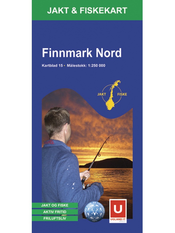
Maps Norway

Norsko

Do Norska jedině s mapou od nás. Dovážíme přesné a podrobné mapy vydané v Norsku. Obsahují aktuální stavy silnic i plánované nové úseky. Dovíte se kde je třeba zastavit a kudy povede trasa vašeho výletu.

Norsko

Grid
List

There are 82 products.

Showing 1-20 of 82 item(s)

Map of Norway 1: 800 000 - Norge Easy Map

One-sided tourist map with hiking and biking trails, camping sites, camps, churches, tourist information centers, NP borders, cultural and historical monuments. The most interesting sites are marked with a number and separately described on the reverse side of the text (Swedish, English, German). scale 1: 800,000
Kč 351
Out-of-Stock

OSLO city center map - OSLO sentrum CK59, 1: 4000, 1: 7000

A detailed map of Oslo city center suitable for hikers. It contains all public transport stations, important shops, monuments and important places. Scale 1: 7,000, Aker Brygge area and center 1: 400. On the back is also well-arranged map of public transport in scale 1: 40.000 and list of restaurants. There is a street index. Published in Norway.
Kč 439
Out-of-Stock

Jotunheimen West - tourist map 1:50 000 Phone Maps

Detailed tourist map of the western part of the Norwegian Jotunheimen National Park and the southern and central part of the Breiheimen National Park. Made of weather-resistant paper. Scale 1:50 000. You can upload the map for free to your mobile phone using PhoneMaps!
Kč 439
In Stock
View Detail

Hoyfjellskart Lofoten: Austvagoya - Svolvar - tourist map...

One of three unique maps with lots of details that have never been shown on a Lofoten map. The terrain information on the map is based on a laser scan from an airplane. For the first time, mountain slopes, larger rocks, streams and glaciers appear with an accuracy that corresponds to reality. The 1:30,000 scale map provides good support for those who go...
Kč 549
In Stock
View Detail

Hoyfjellskart Lofoten: Moskenes - tourist map Lofoten...

One of three unique maps with lots of details that have never been shown on a Lofoten map. The terrain information on the map is based on a laser scan from an airplane. For the first time, mountain slopes, larger rocks, streams and glaciers appear with an accuracy that corresponds to reality. The 1:30,000 scale map provides good support for those who go...
Kč 549
Out-of-Stock

Autoatlas Norsko 1:250 000/1:400 000

NOVÉ VYDÁNÍ. Automapa celého Norska, měřítko 1:250 000 pro jižní část a sever Norska pak 1:400 000, listy na spirále. Obsahuje i plány měst, kempy, hřiště, zajímavosti a místa k výhledu. Rozsáhlý rejstřík i s poštovními kódy (PSČ).
Kč 768
In Stock
View Detail

Galdhopiggen 1:25.000, hiking map

Detailed tourist map of the highest mountain Scandinavia Galdhopiggen in Jotunheimen Park. Drawn access roads from the catchment of Juvasshytta and the village of Spiterstulen. A detailed map in the 1:25 000 scale. Winter skiing routes are also marked. Suitable for navigation on and off marked roads. Released in Norway.
Kč 659
In Stock
View Detail

Experience Guide South Norway 1: 250,000, Opplevelsesguide

Map with tips for the southernmost part of Norway from the E39 and E18 along the coast from Tonsberg to Kristiansadn to Stavanger. It ends under the Hardangervidda National Park. One in a scale of 1: 250,000. The stacked map contains tips on places of interest with information and contacts. Labels in English, Norwegian and German.
Kč 659
Out-of-Stock

Mapa Aurlandsfjellet, Nasjonale turistveger

Aurlandsfjellet National Road Map (Route No. 243) at a scale of 1: 50,000. It features famous places like Stegastein, Naeroeyfjord, the Laerdal tunnel. There are also 5 quality views from this area of ​​Norway. The stacked map is in the hardboard cover. Information in English, Norwegian and German.
Kč 659
In Stock
View Detail

CK52 Lofoten 1:220.000 - road map

A detailed car map of Lofoten archipelago and the western part of the Vesterala archipelago. Detailed maps of cities and places of interest in a scale of 1: 15,000. Map at 1: 220,000 scale. Suitable for navigation on and off marked roads. Released in Norway. Explanations in Norwegian, English and German.
Kč 659
Out-of-Stock

Experienced Guide to Gudbrandsdalen 1:250 000,...

Map with tips for the longest valley of central Norway in one on a scale of 1: 250,000. The stacked map contains tips on places of interest with information and contacts. Includes the area part along the E6 Hamar - Dombas Road, and the Osterdalen Elverum - Alvdal Road No. 3 and the Sognefjellet and Filefjell Highways. Labels in English, Norwegian and German.
Kč 659
Out-of-Stock