List of products by brand Nordeca

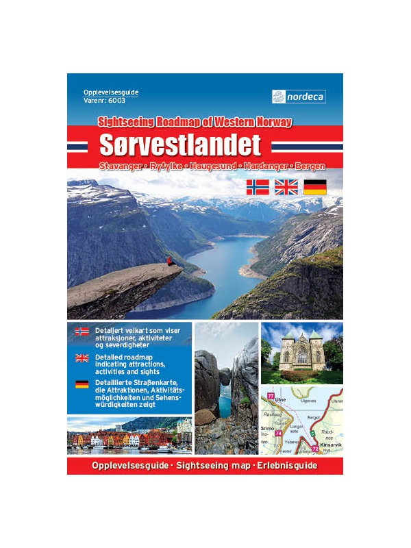
Experienced Guide to Southwest Norway 1: 250,000,...

Map with tips for southwest Norway in one on a scale of 1: 250,000. The stacked map contains tips on places of interest as well as information and contacts. Jaren and Stavanger via Haugesund to Bergen, from Ryfylke and Hardanger to Vosse, through Setesdal, to Haukeli and Roldal. Labels in English, Norwegian and German.
Kč 659
Out-of-Stock

Experienced Guide to Lofoten 1:250 000, Opplevelsesguide

Map with tips for Lofoten in one on a scale of 1: 250,000. The folded map contains tips on interesting places on Lofotech with information and contacts. The area from Bodo via Salten, Rognan and Fauske, Ofoten with Narvik, Vesteralen - Andoya and Lofoten up to the village A. Labels in English, Norwegian and German.
Kč 659
Out-of-Stock

Hiking map Lysefjorden 1:50.000

Detailed tourist map of Lysefjorden, Preikestolen, Kjerag, etc. Detailed map in 1:50 000 scale. Detailed map of hiking trails and mountain chalets. Suitable for navigation on and off marked roads. Released in Norway.
Kč 714
Out-of-Stock

Lofoten 1:100.000

A detailed tourist map of the Lofoten archipelago. Detailed map in 1: 100,000 scale. Detailed mapping of hiking trails and mountain chalets. Suitable for navigation on and off marked roads. Released in Norway.
Kč 714
Out-of-Stock

Bergen - 7 fjellsturen - 1:25.000

A detailed tourist map of the popular march over 7 peaks around Bergen - Bergen - 7 fjellsturen. Detailed map at 1:25 000. Released in Norway. Explanations in Norwegian and English. Summary information about the map in English.
Kč 659
Out-of-Stock

Hiking map Romsdalen 1:100.000

A detailed tourist map of the Romsdalen valley, including popular Trollveggen, Trollstigen, Geirangerfjord, and NP Reinheimen. Detailed map in 1: 100,000 scale. Detailed mapping of hiking trails and mountain chalets. Suitable for navigation on and off marked roads. Released in Norway.
Kč 659
Out-of-Stock

Folgefonna - Hardangerfjorden 1:100.000

Detailed tourist map of Folgefonna National Park and the glaciers of the Hardanger Fjord. Detailed map in 1: 100,000 scale. Detailed mapping of hiking trails and mountain chalets. Suitable for navigation on and off marked roads. Released in Norway.
Kč 659
Out-of-Stock

Varanger, Nasjonale turistveger

Map of the National Autoturist Route along the Varang peninsula in the 1 / 100,000 scale. There are also 5 quality views from this area of ​​Norway. The stacked map is in the hardboard cover. Information in English, Norwegian and German
Kč 659
Out-of-Stock

Helgelandskysten, Nasjonale turistveger

Map of the National Car Travel Route along the coast along Route 17 - Helgelandskysten on a scale of 1: 250,000. There are also 5 quality views from this area of ​​Norway. The stacked map is in the hardboard cover. Information in English, Norwegian and German.
Kč 659
Out-of-Stock

Map Hardangervidda, Nasjonale turistveger

Map of the National Autoturist Route through the Hardangervidda Plateau at a scale of 1: 50,000. There are also 5 quality views from this area of ​​Norway. The stacked map is in the hardboard cover. Information in English, Norwegian and German.
Kč 659
Out-of-Stock

Map Hardanger, Nasjonale turistveger

Map of the National Carriage Route along the Hardanger Fjord at a scale of 1: 75,000. There are also 5 quality views from this area of ​​Norway. The stacked map is in the hardboard cover. Information in English, Norwegian and German.
Kč 659
Out-of-Stock

Tourist Map Besseggen 1: 25.000

Detailed tourist map of the Bessegen ridge in Jotunheimen Park. A detailed map in the 1:25 000 scale. Winter skiing routes are also marked. Suitable for navigation on and off marked roads. Released in Norway.
Kč 659
Out-of-Stock

Map Lofoten, Nasjonale turistveger

Map of the National Car Route on the Lofoten Archipelago at a scale of 1: 100,000. There are also 5 quality views from this area of ​​Norway. The stacked map is in the hardboard cover. Information in English, Norwegian and German
Kč 659
Out-of-Stock

Ryfylke, Nasjonale turistveger

Map of the National Autopathic Route by the Ryfylke Region above Stavanger at a scale of 1: 105,000. There are also 5 quality views from this area of ​​Norway. The stacked map is in the hardboard cover. Information in English, Norwegian and German.
Kč 659
Out-of-Stock