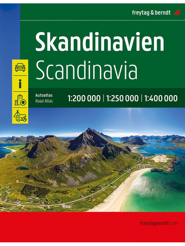
Sweden maps

Švédsko

Podrobné mapy Švédska rozdělené do několika oblastí. V nabídce najdete i přesnou mapu legendárního běžeckého závodu Vasaloppet nebo švédských národních parků.

Švédsko

Grid
List

There are 38 products.

Showing 1-20 of 38 item(s)

Automapa Švédsko 1:600 000

Oboustranná skládaná automapa celého Švédska. Měřítko 1:600 000. Rejstřík míst + plánek center měst Göteborg, Linköping, Stockholm, Sundsvall, Umeea, Uppsala
Kč 361
In Stock
View Detail

Map Sweden 3 - Östra Svealand - 1: 250,000

Part 3 of the detailed map of Sweden, scale 1: 250,000, includes the southeast of Sweden - Östra Svealand, includes the capital Stockholm, then Uppsala - Norrköping - Linköping and the Falun mountain resort. Folded autoturistic map. Released in Sweden.
Kč 351
In Stock
View Detail

Map of Öland 1: 100 000

One-sided tourist map with hiking and biking trails, camping sites, camps, churches, tourist information centers, NP borders, cultural and historical monuments. The most interesting sites are marked with a number and separately described on the reverse side of the text (Swedish, English, German).
Kč 351
In Stock
View Detail

Map KUNGSLEDEN Abisko - Kebnekaise 1:50 000

One-sided tourist map with hiking and biking trails, camping sites, camps, churches, tourist information centers, NP borders, cultural and historical monuments. The most interesting sites are marked with a number and separately described on the reverse side in a text section (Swedish, English).
Kč 659
In Stock
View Detail

Map KUNGSLEDEN Kebnekaise - Saltoluokta 1:50 000

One-sided tourist map with hiking and biking trails, camping sites, camps, churches, tourist information centers, NP borders, cultural and historical monuments. The most interesting sites are marked with a number and separately described on the reverse side in a text section (Swedish, English).
Kč 659
In Stock
View Detail

Map KUNGSLEDEN Saltoluokta - Kvikkjokk 1:50 000

One-sided tourist map with hiking and biking trails, camping sites, camps, churches, tourist information centers, NP borders, cultural and historical monuments. The most interesting sites are marked with a number and separately described on the reverse side in a text section (Swedish, English).
Kč 659
In Stock
View Detail

Map KUNGSLEDEN Kvikkjokk - Adolfstrom 1:50 000

One-sided tourist map with hiking and biking trails, camping sites, camps, churches, tourist information centers, NP borders, cultural and historical monuments. The most interesting sites are marked with a number and separately described on the reverse side in a text section (Swedish, English).
Kč 659
In Stock
View Detail

Map KUNGSLEDEN Adolfstrom - Hemavan 1:50 000

One-sided tourist map with hiking and biking trails, camping sites, camps, churches, tourist information centers, NP borders, cultural and historical monuments. The most interesting sites are marked with a number and separately described on the reverse side in a text section (Swedish, English).
Kč 659
In Stock
View Detail

Z51 Are - tourist map 1:50 000

Detailed tourist map Are. Suitable for tourist guides, travelers and adventurers. Roads for snowmobiles are also marked. The map is printed on paper that resists weather. Texts only in Swedish, well-arranged information and legend in English and German.
Kč 659
In Stock
View Detail

BD4 Kiruna Fjällkarta 1:100.000

A detailed tourist map of the area around the Swedish city of Kiruna. Suitable for tourist guides, travelers and adventurers. Trails for snowmobiles are also marked. The map is printed on paper that resists weather. Texts only in Swedish, clear information and legends in English and German.
Kč 494
zašleme do 24 hodin
View Detail

BD6 Abisko-Kebnekaise-Narvik 1:100.000

A detailed tourist map of the Swedish National Park Abosko. Suitable for tourist guides, travelers and adventurers. Trails for snowmobiles are also marked. The map is printed on paper that resists weather. Texts only in Swedish, clear information and legends in English and German.
Kč 494
zašleme do 24 hodin
View Detail