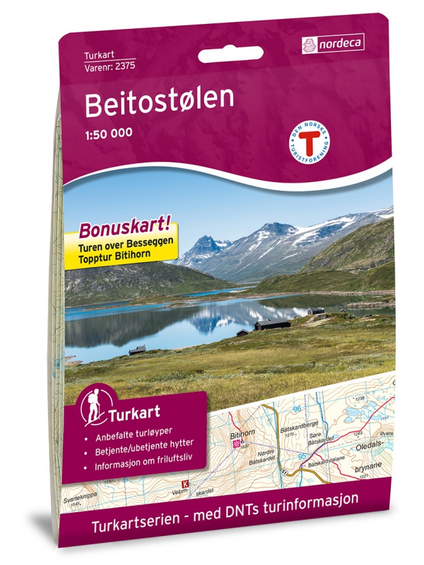
Maps Norway

Norsko

Do Norska jedině s mapou od nás. Dovážíme přesné a podrobné mapy vydané v Norsku. Obsahují aktuální stavy silnic i plánované nové úseky. Dovíte se kde je třeba zastavit a kudy povede trasa vašeho výletu.

Norsko

Car map Norway 1:600,000

Double-sided folded car map of the whole of Norway. Scale 1:600,000. Index of places + city center map of Bergen, Oslo, Trondheim, Narvik, Stavanger, Hammerfest
Kč 361
In Stock
View Detail

Hammerfest Tourist Map, Kvaloya + Soroya, 1: 50.000 - 2 maps

Two maps in one package. Detailed tourist map of the fishing area of Soroya, Kvaloya, Hammerfest. It contains parts of the districts of Kvalsund, Hasvik and Alta in the north of Norway. Detailed map in scale 1:50 000. Detailed drawing of hiking trails and mountain huts. Suitable for navigating on and off marked trails. Released in Norway.
Kč 1,209
In Stock
View Detail

Trondheim 1:50.000

Detailed map of Trondheim and region. Detailed map in 1:50 000 scale. Detailed mapping of hiking trails and mountain chalets. Suitable for navigation on and off marked roads. Released in Norway.
Kč 659
zašleme do 24 hodin
View Detail

Rondane, Nasjonale turistveger

Map of the National Autoturist Route through the Rondane National Park at a scale of 1: 55,000. There are also 5 quality views from this area of ​​Norway. The stacked map is in the hardboard cover. Information in English, Norwegian and German.
Kč 659
In Stock
View Detail

Turkart Rondane - tourist map 1:50,000

This double-sided hiking map covers the whole of Norway's oldest national park, Rondane, with classic hiking destinations such as Rondvassbu, Bjornhollia, Rondeslottet (2178 nm) and Hogronden (2115 nm). The map covers all the most popular mountain areas, marked hiking trails in the vicinity, DNT cabins and private accommodation cabins. It shows marked...
Kč 549
In Stock
View Detail

Hoyfjellskart Jotunheimen: Galdhopiggen + Glittertind -...

A unique map with a lot of detail that has never been shown before in a map of Norway's highest mountain range. It is ideal for those planning to climb Galdhopiggen (2469 m). Terrain information on the map is based on laser scanning from an aircraft. For the first time, mountain slopes, larger rocks, watercourses and glaciers appear with an accuracy that...
Kč 659
In Stock
View Detail

Balestrand Tourist Map 1:50 000

A detailed tourist map of the Sognefjord, includes Balestrand, Vangsnes, Hella, Dragsvik, Gaularfjellet Mountain Road. Detailed map in 1:50 000 scale. Suitable for navigating on and off marked trails. Released in Norway.
Kč 714
In Stock
View Detail

Hurrungane Tourist Map 1: 25.000

Detailed tourist map of Hurrungane mountains in the Jotunheimen park area near the 55 Sognefjellet road. Includes Fannaraki Glacier, Sognefjellshytta, Fannarakhytta, Grandalen, Ingjerdbu, Vettli Gard. Detailed map in 1:25 000 scale. Suitable for navigating on and off marked trails. Released in Norway.
Kč 714
In Stock
View Detail

Beitostolen tourist map 1:50 000

Detailed tourist map of the popular area for downhill and cross-country skiers Beitostolen. The bonus map also includes the crossing of the Besseggen ridge and the hike to the Bitihorn mountain in Jotunheimen Park. Detailed map in 1:50 000 scale. Suitable for navigating on and off marked trails. Released in Norway.
Kč 714
In Stock
View Detail

Tourist map Romsdalseggen 1:25 000

The most detailed tourist map of Romsdalseggen, includes Trollstigen, Trollveggen, Romsdalshornet, Andaslnes, Isfjorden Detailed map in 1:25 000 scale. Suitable for navigating on and off marked trails. Released in Norway.
Kč 714
In Stock
View Detail