Grid
List

There are 103 products.

Showing 21-40 of 103 item(s)

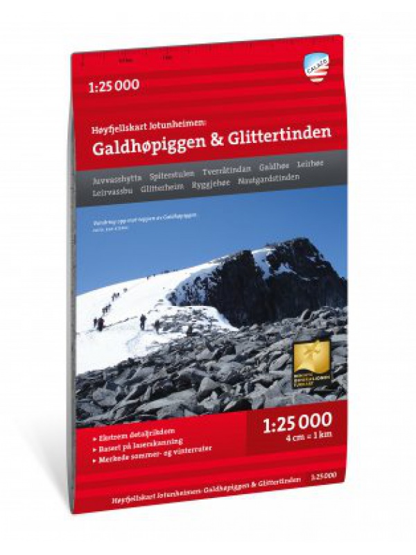
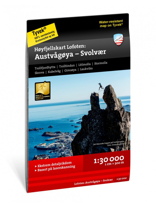
Galdhopiggen 1:25.000, hiking map

Detailed tourist map of the highest mountain Scandinavia Galdhopiggen in Jotunheimen Park. Drawn access roads from the catchment of Juvasshytta and the village of Spiterstulen. A detailed map in the 1:25 000 scale. Winter skiing routes are also marked. Suitable for navigation on and off marked roads. Released in Norway.
Kč 659
In Stock
View Detail

Mapa Aurlandsfjellet, Nasjonale turistveger

Aurlandsfjellet National Road Map (Route No. 243) at a scale of 1: 50,000. It features famous places like Stegastein, Naeroeyfjord, the Laerdal tunnel. There are also 5 quality views from this area of ​​Norway. The stacked map is in the hardboard cover. Information in English, Norwegian and German.
Kč 659
In Stock
View Detail

Veikart Nord-Norge Nord 1:500 000

The last 5th part of north Norway's folding automapap (northern part) with a rich register of places on the back. Includes areas and cities of Tromso, Alta, Hammerfest, Honningsvag, Nordkapp, Vardo, Kirkenes. The latest edition of the Road Statement to Begin 2016. The Distance Table. Labels in Norwegian, English and German. Scale 1: 500,000.
Kč 659
zašleme do 24 hodin
View Detail

Rallarvegen 1:50.000

Detailed tourist and cycle map of the Rallarvegen area. Detailed map in 1:50 000 scale. Detailed mapping of hiking trails and mountain chalets. Suitable for navigation on and off marked roads. Released in Norway.
Kč 659
zašleme do 24 hodin
View Detail

Trolltunga, Odda - Ullensvang 1:50.000

Detailed map of Trolltunga, Odda - Ullensvang. Detailed map in 1:50 000 scale. Detailed mapping of hiking trails and mountain chalets. Suitable for navigation on and off marked roads. Released in Norway.
Kč 714
zašleme do 24 hodin
View Detail

Oyer - Lillehammer 1:50.000

Detailed map of Oyer - Lillehammer. Detailed map in 1:50 000 scale. Detailed mapping of hiking trails and mountain chalets. Suitable for navigation on and off marked roads. Released in Norway.
Kč 659
zašleme do 24 hodin
View Detail

Birkebeiner -  1:50.000

A detailed tourist map of the popular Birken (Birkebeiner) from Reny to Lillehammer. The race has its well-known winter version of Birkebeinerrennet, but also cross-country and cycling. Detailed map in 1: 100,000 scale. Detailed mapping of hiking trails and mountain chalets. Suitable for navigation on and off marked roads. Released in Norway.
Kč 659
In Stock
View Detail

Atlanterhavsvegen, Nasjonale turistveger

Map of the National Autoturistical Route Atlanterhavsvegen along the bridges and islands on the Atlantic Ocean between Molde and Kristiansund. There are also 5 quality views from this area of ​​Norway. The stacked map is in the hardboard cover. Information in English, Norwegian and German
Kč 659
In Stock
View Detail

Tourist Map Breheimen 1: 50.000

Detailed tourist map of the Breheimen National Park. Detailed map in 1:50 000 scale. Detailed mapping of hiking trails and mountain chalets. Suitable for navigation on and off marked roads. Released in Norway.
Kč 659
In Stock
View Detail

Map Jaeren, Nasjonale turistveger

Map of the National Carriage Route through the coastal region Jaeren under Stavanger at the scale of 1: 100,000. There are also 5 quality views from this area of ​​Norway. The stacked map is in the hardboard cover. Information in English, Norwegian and German.
Kč 659
In Stock
View Detail

Valdresflye, Nasjonale turistveger

Map of the National Autoturist Route through the Valdresfly Pass at a scale of 1: 50,000. There are also 5 quality views from this area of ​​Norway. The stacked map is in the hardboard cover. Information in English, Norwegian and German.
Kč 659
In Stock
View Detail

Hoyfjellskart Senja: Keipen, Tredjefjellet & Kvanan -...

Tourist map showing the northwestern part of Senja Island at a scale of 1:25,000. Useful especially if you are planning a trip to the top of Keipen (938 m), Breitinden (1001 m) or Kvanan (963 m) or you want to leave the marked paths and go into the mountains on your own fist. Thanks to the Tyvek® material, it is completely waterproof and highly...
Kč 549
In Stock
View Detail

Hoyfjellskart Jotunheimen: Galdhopiggen & Glittertinden -...

The highly detailed hiking map of Scandinavia's highest mountains is unique in that the terrain information on the map is based on laser scanning from an aircraft. Mountain slopes, waterways, glaciers and other natural elements are shown in much more detail with this technology. The map also contains more trails than any previous map of the same area. The...
Kč 549
In Stock
View Detail

Turkart Senja - tourist map 1:50,000

This double-sided tourist map covers the entire island of Senja with its high, steep mountains and typical alpine feel. It is part of Calazo's modern map series with unique terrain information based on laser scanning from aircraft. Thanks to the Tyvek® material, it is completely waterproof and highly tear-resistant.
Kč 549
In Stock
View Detail

Hoyfjellskart Hogruta - tourist map 1:25.000

Hogruta Jotunheimen leads through the most beautiful mountain passes and the highest peaks of Scandinavia. This 1:25,000 scale alpine map contains terrain information based on laser scanning from an aircraft. The map shows the "original" Hogwarts from 2014, as well as various frequently used alternatives. Thanks to the Tyvek® material, it is completely...
Kč 549
In Stock
View Detail

Hoyfjellskart Lofoten: Austvagoya - Svolvar - tourist map...

One of three unique maps with lots of details that have never been shown on a Lofoten map. The terrain information on the map is based on a laser scan from an airplane. For the first time, mountain slopes, larger rocks, streams and glaciers appear with an accuracy that corresponds to reality. The 1:30,000 scale map provides good support for those who go...
Kč 549
In Stock
View Detail